
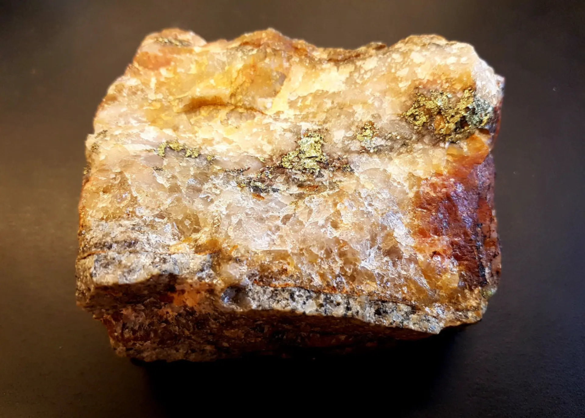
MK-21-018
12.14 g/t Au over 8 m
within broader intercept of 24.7 m @ 4.05 g/t Au

The Property
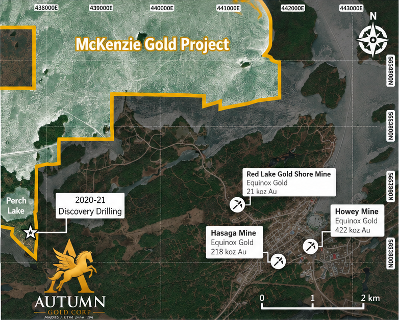
Advancing the 100%-owned McKenzie Gold Project — 1,398 hectares with nearly 500 m of drilled strike in the Red Lake gold camp.
Property Overview
In the Heart of Red Lake
1,398 hectares in a single block along the southern part of Red Lake, near producing mines and past producers.
Shallow and Open
The first 30 holes established nearly 500 m of mineralized strike, from surface to 300 m depth. The zone is trending north and northwest across Perch Lake.
Two Mineralization Styles
High-grade quartz veins carrying visible gold occur within broad 1 g/t Au intercepts through the intrusives.
Access and Neighbours
~4 km west of Hasaga, near ground held by Evolution, Equinox and West Red Lake Gold. Paved roads and an existing power line serve the district.
Hover or tap any mine on the map to see its owner, production and years here.
Perch Zone 2020-21 Discovery
Maiden drilling in 2020-21 resulted in a significant Red Lake discovery
The Perch Zone discovery combines narrow, high-grade gold assays with lengthy intercepts averaging around 1 g/t Au extending into the intrusives.
27 of 30
90% success rate
Of the first 30 holes drilled in the Perch Zone in 2020-2021, 27 returned at least one reported intercept at or above 1 g/t Au.
| Reported length | Intercepts ≥1 g/t Au | Qualifying holes |
|---|---|---|
| Any length | 142 | 27 |
| ≥1 m | 137 | 25 |
| ≥5 m | 30 | 10 |
| ≥10 m | 17 | 7 |
| ≥25 m | 7 | 3 |
| ≥50 m | 3 | 3 |
Counts include separately reported overlapping intercepts and higher-grade intercepts; they are not additive or independent zones. Length thresholds are cumulative. Reported lengths are downhole, not true widths. Historical 2020–2021 results; no current mineral resource estimate. Hasaga Property Mineral Resource Statement, effective 30 June 2024: indicated 1,470 kt @ 8.64 g/t Au for 408 koz; inferred 2,059 kt @ 7.31 g/t Au for 484 koz, at a 4.0 g/t Au cut-off. Reviewed and approved by Scott Heffernan, M.Sc., P.Geo., EVP Exploration, Equinox Gold. Not verified by Autumn Gold Corp. Nearby mineralization is not necessarily indicative of McKenzie.
Perch Zone Discovery · 2020–2021
MK-21-018
12.14 g/t Au over 8 m
within broader intercept of 24.7 m @ 4.05 g/t Au
MK-21-019
1.25 g/t Au over 136.5 m
including 44.9 m @ 3.00 g/t Au, 15.5 m @ 5.25 g/t Au and 1 m @ 59.80 g/t Au
MK-21-018 · Upper Zone
1.01 g/t Au over 56 m
including 21.5 m @ 1.84 g/t Au, 10 m @ 3.30 g/t Au and 1 m @ 23.10 g/t Au
MK-20-006 · High Grade
13.25 g/t Au over 2.75 m
including 36.2 g/t Au over 1 m
Reported lengths are downhole intercepts and are not true widths. Grades are uncapped.
Red Lake 100m+ Gold Intercepts
| Rank | Year | Project | Hole | Length (m) | Grade (g/t Au) | Company |
|---|---|---|---|---|---|---|
| 1 | 2020 | Great Bear / Dixie | BR-118 | 104.15 | 2.67 | Great Bear Resources |
| 2 | 2015 | Hasaga | HLD004 | 122.5 | 1.61 | Premier Gold |
| 3 | 2021 | McKenzie | MK-21-019 | 136.5 | 1.25 | Autumn Gold Corp. |
| 4 | 2017 | Hasaga | HMP161 | 181.0 | 1.21 | Premier Gold |
| 5 | 2015 | Hasaga | HMP024 | 107.0 | 1.19 | Premier Gold |
| 6 | 2016 | Hasaga | HMP106 | 117.0 | 1.18 | Premier Gold |
| 7 | 2016 | Hasaga | HLD052 | 177.0 | 1.09 | Premier Gold |
| 8 | 2021 | Great Bear / Dixie | BR-306 | 106.7 | 1.08 | Great Bear Resources |
| 9 | 2016 | Hasaga | HLD060 | 193.0 | 1.04 | Premier Gold |
Only nine identified in ~40 years of reported drilling. Seven of the nine occur at McKenzie and nearby Hasaga.
Source: Review of publicly available historical and modern drill results in the Red Lake Gold District. Reported intervals are generally core/downhole lengths and may not represent true widths. The review is not an exhaustive audit of every historical drill assay in the district. Third-party results have not been verified by the Company's QP. Mineralization on nearby properties is not necessarily indicative of mineralization at McKenzie.
Perch Zone Discovery 2020-2021
13 reported intercepts of 10 g/t Au and better, over a minimum of 1 metre
8 intercepts greater than 20 g/t Au in the first 30 drill holes in the Perch Zone
| Drill hole | From (m) | To (m) | Length (m) | Grade (g/t Au) |
|---|---|---|---|---|
| MK-20-06 | 68.75 | 71.50 | 2.75 | 13.25 |
| MK-20-06 | 69.50 | 70.50 | 1.00 | 36.20 |
| MK-21-18 | 22.00 | 23.00 | 1.00 | 23.10 |
| MK-21-18 | 86.30 | 94.30 | 8.00 | 12.14 |
| MK-21-18 | 86.30 | 92.30 | 6.00 | 16.09 |
| MK-21-18 | 88.30 | 89.30 | 1.00 | 94.20 |
| MK-21-19 | 149.50 | 150.50 | 1.00 | 59.80 |
| MK-21-19 | 150.50 | 151.50 | 1.00 | 15.50 |
| MK-21-19 | 180.40 | 181.40 | 1.00 | 26.70 |
| MK-21-24 | 65.00 | 66.00 | 1.00 | 21.00 |
| MK-21-24 | 70.50 | 72.00 | 1.50 | 24.50 |
| MK-21-25 | 66.00 | 68.00 | 2.00 | 10.21 |
| MK-21-25 | 66.00 | 67.00 | 1.00 | 23.70 |
Intercepts include overlapping higher-grade intercepts and are not additive. Reported lengths are downhole lengths, not true widths.
Source: supplied drill-results summary, citing NI 43-101 Technical Report, McKenzie Project (Kenwood, April 25, 2022). Historical drilling results.
Perch Zone Discovery 2020-2021
14 reported intercepts across 9 holes, grading ≥0.50 g/t Au, including overlapping intercepts
7 intercepts at 1 g/t Au and higher over 29m or more in the first 30 drill holes in the Perch Zone
| Drill hole | From (m) | To (m) | Length (m) | Grade (g/t Au) | |
|---|---|---|---|---|---|
| MK-20-008 | 5.5 | 123.0 | 117.5 | 0.62 | |
| MK-20-008 | including | 67.5 | 123.0 | 55.5 | 1.00 |
| MK-21-017 | 287.2 | 327.5 | 40.3 | 0.58 | |
| MK-21-018 | 13.0 | 69.0 | 56.0 | 1.01 | |
| MK-21-018 | 77.9 | 115.5 | 37.6 | 2.78 | |
| MK-21-018 | including | 86.3 | 115.5 | 29.2 | 3.43 |
| MK-21-019 | 148.5 | 285.0 | 136.5 | 1.25 | |
| MK-21-019 | including | 149.5 | 194.4 | 44.9 | 3.00 |
| MK-21-019 | including | 165.0 | 194.4 | 29.4 | 1.82 |
| MK-21-020 | 48.0 | 84.0 | 36.0 | 0.55 | |
| MK-21-022 | 43.2 | 86.0 | 42.8 | 0.54 | |
| MK-21-028 | 203.0 | 276.0 | 74.0* | 0.65 | |
| MK-21-029 | 132.0 | 265.0 | 133.0 | 0.52 | |
| MK-21-030 | 75.0 | 100.0 | 25.0 | 0.52 |
Source: McKenzie NI 43-101 Technical Report (July 28, 2026), Tables 7-9. Reported intercepts are downhole lengths, not true widths.
Overlapping intercepts are not additive. Whole-hole averages are excluded. *MK-21-028: source reports 74 m, but depths 203-276 m span 73 m.
Historical 2020-2021 drilling results. No current mineral resource estimate.
McKenzie · Perch Zone
REPORTED INTERVALS BY LENGTH AND GRADE THRESHOLD
Red Lake, Ontario
First 30 holes drilled in the Perch Zone
27 of 30 holes (90%)returned at least one interval of ≥1 g/t Au
| Length threshold (at ≥1 g/t Au) | Number of reported intervals (includes higher-grade sub-intervals) | % of total (142 intervals) | Number of holes with at least one interval at this threshold (30 holes total) |
|---|---|---|---|
| All lengths (≥1 g/t Au) | 142 | 100% | 27 |
| ≥1 metre | 137 | 96% | 25 |
| ≥5 metres | 30 | 21% | 10 |
| ≥10 metres | 17 | 12% | 7 |
| ≥25 metres | 7 | 5% | 3 |
| ≥50 metres | 3 | 2% | 3 |
| ≥25 metres (0.50 – 1.00 g/t Au) | 7 | 5% | 5 |
| Drill hole | From (m) | To (m) | Length (m) | Grade (g/t Au) |
|---|---|---|---|---|
| MK-20-06 | 68.75 | 71.50 | 2.75 | 13.25 |
| MK-20-06 | 69.50 | 70.50 | 1.00 | 36.20 |
| MK-21-18 | 22.00 | 23.00 | 1.00 | 23.10 |
| MK-21-18 | 86.30 | 94.30 | 8.00 | 12.14 |
| MK-21-18 | 86.30 | 92.30 | 6.00 | 16.09 |
| MK-21-18 | 88.30 | 89.30 | 1.00 | 94.20 |
| MK-21-19 | 149.50 | 150.50 | 1.00 | 59.80 |
| MK-21-19 | 150.50 | 151.50 | 1.00 | 15.50 |
| MK-21-19 | 180.40 | 181.40 | 1.00 | 26.70 |
| MK-21-24 | 65.00 | 66.00 | 1.00 | 21.00 |
| MK-21-24 | 70.50 | 72.00 | 1.50 | 24.50 |
| MK-21-25 | 66.00 | 68.00 | 2.00 | 10.21 |
| MK-21-25 | 66.00 | 67.00 | 1.00 | 23.70 |
| Drill hole | From (m) | To (m) | Length (m) | Grade (g/t Au) | Notes |
|---|---|---|---|---|---|
| MK-21-019 | 148.5 | 285.0 | 136.5 | 1.25 | Longest interval; Includes higher-grade runs |
| MK-21-018 | 13.0 | 69.0 | 56.0 | 1.01 | Includes higher-grade runs |
| MK-20-008 | 67.5 | 123.0 | 55.5 | 1.00 | Includes higher-grade run |
| MK-21-019 | 149.5 | 194.4 | 44.9 | 3.00 | High-grade interval |
| MK-21-018 | 77.9 | 115.5 | 37.6 | 2.78 | Includes 29.2 m @ 3.43 g/t Au |
| MK-21-019 | 165.0 | 194.4 | 29.4 | 1.82 | including |
| MK-21-018 | 86.3 | 115.5 | 29.2 | 3.43 | Within 37.6 m interval above |
Note: Counts include all separately reported assay intervals from drill holes MK-20-001 to MK-21-030, including higher-grade sub-intervals listed as “Includes” within broader intervals. Intervals are downhole lengths, not true widths.
Source: NI 43-101 Technical Report, McKenzie Project (Kenwood, April 25, 2022). Results are from historical drilling and should not be relied upon to be precise. For information purposes only.
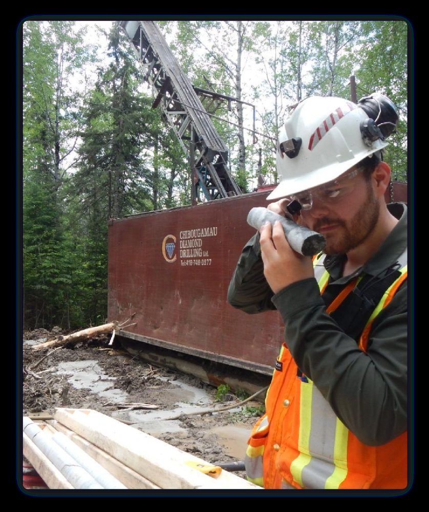
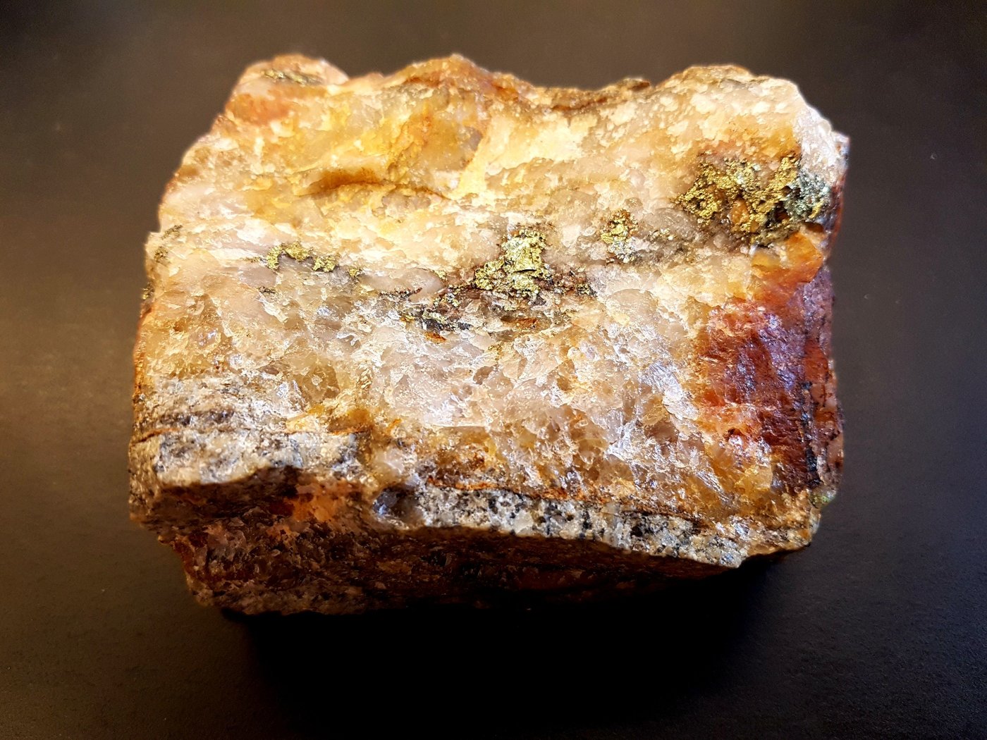
Drill Core
Free gold and coarse pyrite logged through the 2021 program — the same veins that returned single metres of 23.10, 59.80 and 94.20 g/t Au.
Core photographs illustrate mineralization styles and do not establish grade.
Perch Zone Strike Extension
Establishing consistent mineralization north, northwest and west of Perch Lake offers significant upside.
Limited drilling and sampling in 2021 confirmed mineralization is trending towards untested areas of interest.
MK-21-24
2.19 g/t Au over 22 m
including 1.5 m @ 24.5 g/t Au
MK-21-25
10.21 g/t Au over 2 m
| Grab Samples (g/t Au) | |
|---|---|
| 13.4 | 7.70 |
| 6.83 | 3.54 |
| 3.51 | 1.13 |
| 1.08 | 1.08 |
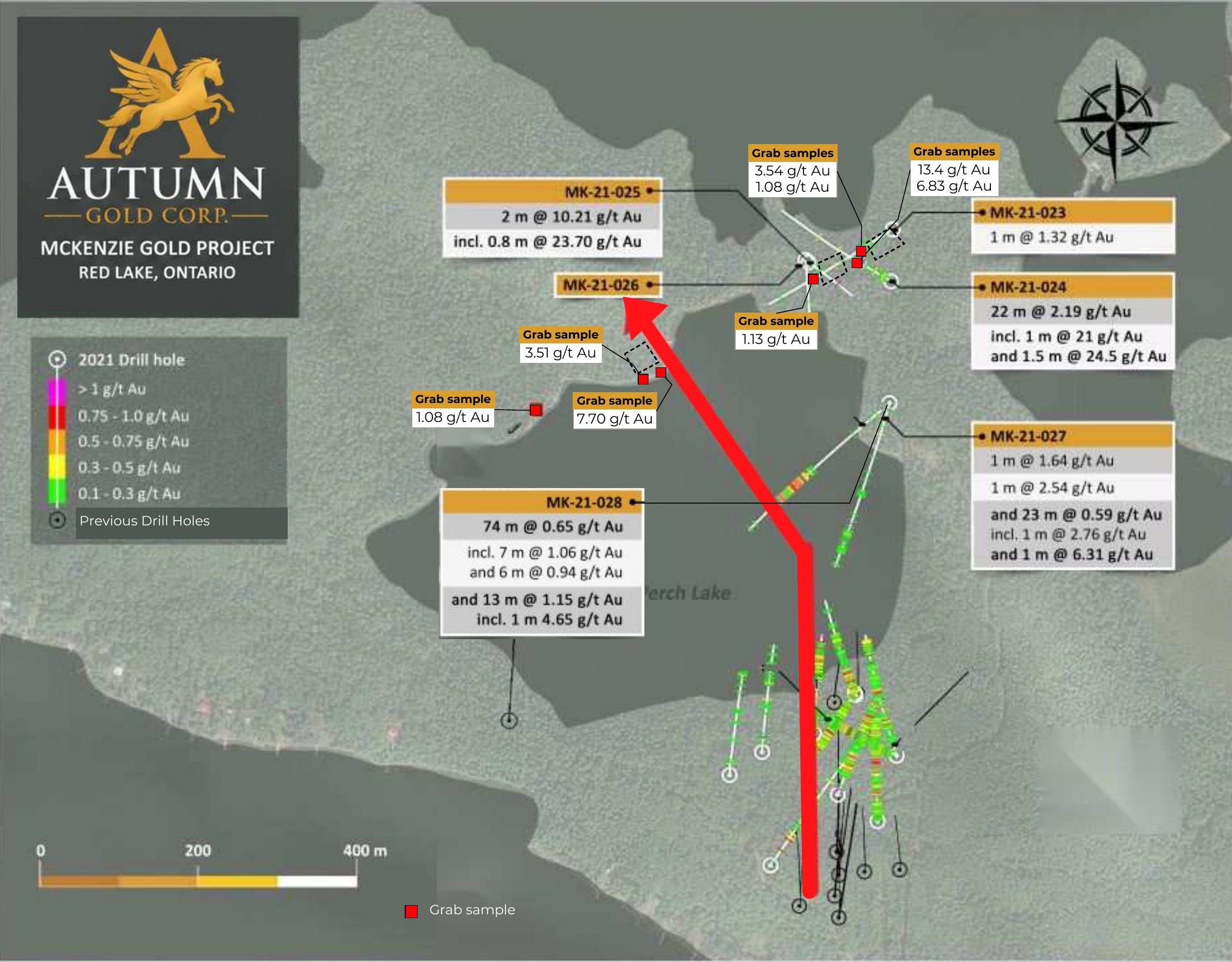
Source: McKenzie NI 43-101 Technical Report (July 28, 2026).
Grab samples are selective by nature and are not necessarily representative of the true distribution, thickness, or average grade of the mineralization across the property
Additional Zone of Interest · Historical Results
In addition to the Perch Zone, McKenzie Island offers a compelling second exploration opportunity with demonstrated high-grade gold, multiple targets and limited modern follow-up.
Historical grab samples up to
331.14 g/t Au
and multiple additional high-grade occurrences.
| Year | Area / Operator | Result | Type |
|---|---|---|---|
| 2017 | Southwest McKenzie Island (Cypress) | 331.14 g/t Au | Grab sample |
| Historical | Southwest McKenzie Island | 212.8 g/t Au | Surface showing |
| 2017 | Northern shoreline | 18.02 g/t Au | Grab sample |
| 1937 | MacAndrew vein | 12.92 g/t Au over 0.6 m | Drilling |
| 1962 | Western McKenzie Island (Juma) | 3.40 g/t Au over 0.7 m | Drilling |
| 1986 – 1988 | Dome Stock (Pure Gold – Noramco) | Up to 2.696 g/t Au | Sampling |
Sources: Ontario assessment files 52N04SW0020, 52N04SW0026 and 52N04SW2068. Historical grab samples are selective and may not represent average grades. Historical drill intercepts are reported downhole lengths; true widths have not been established. The property has no current mineral resource estimate.
What Comes Next
Post-IPO plan: 2000 metres of Perch Zone definition drilling scheduled for spring/summer 2027
Infill and extend the nearly 500 m of established strike, including below MK-21-019, where the hole was terminated while still in gold mineralization.
Define the known system
Explore and identify new zones across and beyond Perch Lake, along the trend interpreted from the 2021 drilling, where the system is untested.
Grow the footprint
Compile drilling, assay and structural data to support a preliminary resource estimate on the St. Paul's Bay area. Two campaigns of assay and collar data are already in hand.
Toward a maiden estimate
These are planned objectives, subject to financing, permits and approvals. No mineral resource or mineral reserve has been estimated at McKenzie.
Investor Updates
Join the investor list to receive updates from Autumn Gold Corp.